Ensemble Machine Learning and Derivative Spectroscopy for Robust Estimation of Plant Physiological Traits in Precision Viticulture
Marco Lutz
Technical University of Applied Sciences Würzburg-Schweinfurt, Faculty of Plastics Engineering and Surveying, Würzburg, Germany
Daniel Heßdörfer
Bavarian State Institute for Viticulture and Horticulture (LWG), Veitshöchheim, Germany
Tobias Ullmann
University of Würzburg, Departement of Remote Sensing, Institute for Geography and Geology, Würzburg, Germany
Melanie Brandmeier
Technical University of Applied Sciences Würzburg-Schweinfurt, Faculty of Plastics Engineering and Surveying, Würzburg, Germany
Related authors
No articles found.
Julius Kunz, Sebastian Buchelt, Tim Wiegand, Tobias Ullmann, and Christof Kneisel
The Cryosphere, 20, 4255–4275, https://doi.org/10.5194/tc-20-4255-2026, https://doi.org/10.5194/tc-20-4255-2026, 2026
Short summary
Short summary
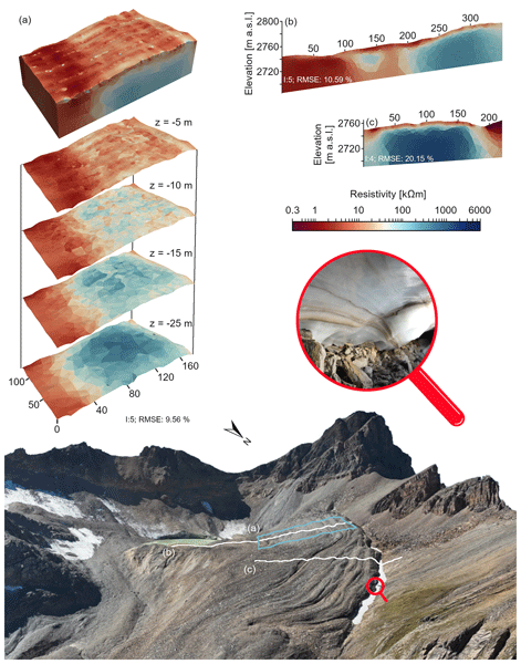
Glacier-permafrost interactions in Alpine environments influence geomorphological processes, making it essential to understand the relationship between subsurface structures and surface morphodynamics for predicting landscape evolution under climate change. This study uses applied geophysics and remote sensing methods to investigate this relationship and to reveal the distribution of different ground ice types, as well as the related surface morphodynamics in three alpine glacier forefields.
Baturalp Arisoy, Florian Betz, Georg Stauch, Doris Klein, Stefan Dech, and Tobias Ullmann
EGUsphere, https://doi.org/10.5194/egusphere-2026-619, https://doi.org/10.5194/egusphere-2026-619, 2026
Short summary
Short summary
Earth Observation archives now encompass multispectral imagery, yet producing analysis-ready Sentinel-2 time series remains a critical bottleneck. We present an open-source Python package that builds data cubes from Spatio-Temporal Asset Catalog catalogues and integrates cloud masking, co-registration, and super-resolution in one workflow. Validated on high-performance computing, it enables rapid, reproducible cube construction and updates, improving temporal consistency in a braided river.
Dilara Kim, Enrico Mattea, Mattia Callegari, Tomas Saks, Ruslan Kenzhebayev, Erlan Azisov, Tobias Ullmann, Martin Hoelzle, and Martina Barandun
EGUsphere, https://doi.org/10.5194/egusphere-2025-3978, https://doi.org/10.5194/egusphere-2025-3978, 2025
Short summary
Short summary
We investigated how the snowline changed on four glaciers in the Pamir and Tien Shan mountain ranges in Central Asia. For this we developed a new method of combining different types of satellite images. This detailed record of snowlines shows for the first time how glaciers are responding to climate change during the dry season on almost daily scale. Our results help to understand better when and how much meltwater stored in glaciers can be used for drinking water by people living downstream.
Julian Fäth, John Friesen, Andrea Sofia Garcia de León, Julia Rieder, Christian Schäfer, Tobias Leichtle, Tobias Ullmann, and Hannes Taubenböck
Int. Arch. Photogramm. Remote Sens. Spatial Inf. Sci., XLVIII-M-7-2025, 267–273, https://doi.org/10.5194/isprs-archives-XLVIII-M-7-2025-267-2025, https://doi.org/10.5194/isprs-archives-XLVIII-M-7-2025-267-2025, 2025
Tobias Ullmann, Eric Möller, Roland Baumhauer, Eva Lange-Athinodorou, and Julia Meister
E&G Quaternary Sci. J., 71, 243–247, https://doi.org/10.5194/egqsj-71-243-2022, https://doi.org/10.5194/egqsj-71-243-2022, 2022
Short summary
Short summary
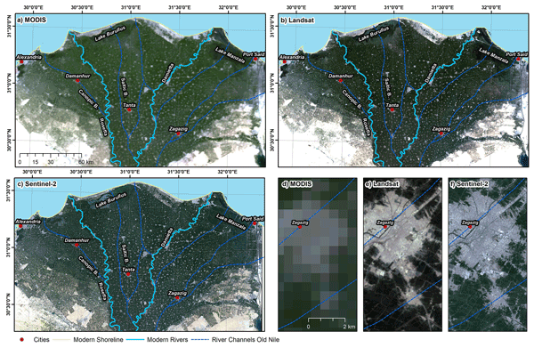
In this contribution we highlight as an example the application of a freely available tool for the Google Earth Engine. The software allows cloud-free satellite images to be processed. We show processing examples for the Nile Delta (Egypt) and how the remote sensing images are used to find hints of buried landforms, such as former river branches of the Nile.
Sebastian Buchelt, Kirstine Skov, Kerstin Krøier Rasmussen, and Tobias Ullmann
The Cryosphere, 16, 625–646, https://doi.org/10.5194/tc-16-625-2022, https://doi.org/10.5194/tc-16-625-2022, 2022
Short summary
Short summary
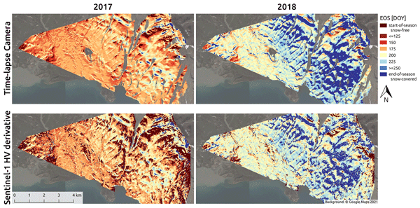
In this paper, we present a threshold and a derivative approach using Sentinel-1 synthetic aperture radar time series to capture the small-scale heterogeneity of snow cover (SC) and snowmelt. Thereby, we can identify start of runoff and end of SC as well as perennial snow and SC extent during melt with high spatiotemporal resolution. Hence, our approach could support monitoring of distribution patterns and hydrological cascading effects of SC from the catchment scale to pan-Arctic observations.